Capitol Historical Report, Block 8 Building 11 Originally entitled: "Capitol Square 8-2"
Colonial Williamsburg Foundation Library Research Report Series - 1115
Colonial Williamsburg Foundation
Library
Williamsburg, Virginia
1990
October 28, 1940
To: Mr. Kendrew
From: H. D. Farish
I am sending herewith the report on Capitol Square 8-2 which we have prepared at your request.
H. D. F.
20:15CAPITOL SQUARE 8 - 21st copy
1940
The first exact information regarding the history of Capitol Square 8-2 is found on the Frenchman's map of 1781 (or 1782, or 1786). This map indicates that there were four (or five) structures in this area which faced on Francis Street, and one which faced on Waller Street. Several small structures are indicated in the rear of these buildings.
Block 8-2 appears at that time to have been divided into two enclosed properties and a larger unenclosed section. On one of the enclosed lots or sections is a rectangular building which is shown facing Francis Street, apparently on the site of the present Ayscough Shop. A smaller building stands in the rear, between the aforementioned building and the Capitol.
On the adjoining lot or division are two rectangular structures facing on Francis Street, with three smaller structures in the rear. To the east of these buildings, on the unenclosed area, and near the corner of Waller Street, there is indicated what appears to be a "double" house or a long single rectangular structure with a center partition, facing on Francis Street.
At approximately the northeast corner of Block 8-2, there is a structure which faces on Waller Street. A smaller structure stands in the rear between the above-mentioned structure and the Capitol enclosure.
The map of Williamsburg made by Benjamin Bucktrout in 1800 shows two roads leading across Capitol Square from the eastern terminus of the Duke of Gloucester Street, both at an angle of approximately 45 degrees to its eastern terminus. One of these roads led towards York and the other towards Capitol Landing. The road leading towards York enters Francis Street at a point directly south of the Capitol. This point falls on the western 2 boundary of Block 8-2.
The Bucktrout map of 1800 indicates that there were at that time three oblong lots in this area in private ownership, in addition to an unenclosed portion of the Capitol Square. One of these lots extended longitudinally along Francis Street toward the east from the point where the York Road intersected Francis Street to the western boundary of another lot which extended lengthwise from Francis Street to the street or entrance way to the Capitol grounds at a point midway along Waller Street.
The Bucktrout map indicates that the first of these privately owned lots (extending lengthwise along Francis Street) was at that time in what was apparently the Joint ownership of persons by the name of Bucktrout and Lacey. There is no definite indication of the division of this lot into two separate properties, but of the two structures on the lot, one appears to have been in the possession of a person or persons named Bucktrout, and the other of a person or persons named, Lacey. The structure which was apparently in the possession of the Bucktrout family stood near the western boundary of the lot, at what was approximately the site of the present Ayscough Shop. A somewhat smaller structure is indicated near the middle of the lot, apparently in the possession of a person or persons named Lacey.
A second lot was contiguous to the "Bucktrout-Lacey" property at the eastern boundary of the latter lot, and extended lengthwise from Francis Street to the street or driveway which entered the Capitol grounds from Waller Street. This lot is indicated as being in the possession of a person or persons named Carter. In contrast to the "Bucktrout-Lacey lot," this lot has no structures indicated upon it.
The adjoining corner lot, which extended along Waller Street from Francis Street to the street or driveway which entered the Capitol see report on Ayscough House - block 8 3 grounds from Waller Street, was then in the possession of a person or persons named Draper. As was the case with the "Carter* lot," no structures are indicated on the "Draper lot."**
A second map of Williamsburg by an unknown draftsman of about the same period (dated by Lyon G. Tyler as c. 1790, but probably of a considerably later date) indicates that the "Bucktrout-Lacey lot" was then apparently in the joint ownership of persons by the names of Bucktrout and Carey. This map shows the "Carter lot" in the possession of a person or persons named Carey. The "Draper lot" is again indicated as in the possession of a person or persons of that name.
Since Block 8-2 lay partly in James City County, where the great bulk of the public records were destroyed or dispersed during the period of the Civil War, it has been impossible to compile a full history of this area from the available records. Of the three lots which were shown in private possession on the map of Bucktrout and that of the unknown draftsman, the history of the "Draper lot" is obscured by fewer complications than the others.
It seems likely that the "Draper lot" had been owned for a number of years at a period prior to the time the above maps were made, by John Draper, a blacksmith and farrier, and that this property had continued in the possession of Draper's widow after his death. John Draper is the only person of that surname who is listed in the Land Tax Records and other public records of the city during the last half of the eighteenth century and the first quarter of the nineteenth century.
During the years 1769-1770, John Draper, "smith and farrier," was located on the "Main Street" of the city. [Virginia Gazette, Rind, 1769, and York County Records, Book 13 Deeds, p. 76.] During the period from 4 January 27, 1776, to July 3, 1776, the government of Virginia issued warrants or paid cash to John Draper on several occasions for guns and sundry other supplies furnished for the "Public service" and for "Express hire." [see Calendar of Virginia State Papers, Vol. VIII, passim, and Virginia Magazine of History and Biography, Vol. XXVII, p. 339; Vol. XXIX, p. 61].
On June 6, 1780, John Draper purchased from Samuel Major a lot in the general vicinity of the lot in question. The deed described the lot purchased by Draper as one "Whereon the Old Play House lately stood, containing 35 feet in length and 30 feet in breadth, and bounded by James Moir's line, the Capitol Square and the street." [York County Records, Book VI Deeds, p. 94.]
The first census of the United States shows that in 1782 John Draper was the head of a household in Williamsburg, which consisted of seven whites and two blacks. [See transcript from Virginia State Library in the Department of Research and Record.] Other records show that John Draper owned a lot or lots in Williamsburg in 1783. [See William and Mary Quarterly, Vol. XI, (1), P. 114.]
John Draper apparently died during the latter part of 1785. [See Humphrey Harwood's Ledger, B, pp. 42, 95; and Williamsburg Land Tax Records, 1785.] During the years 1780-1785, Humphrey Harwood had made repairs on buildings owned by John Draper as revealed by the following accounts:
1784 th To Amt brt from folio III - Ledgr A £17. 9.7½ March 30 To 1 bushel of Corn 5/. . . 5. 1785 th Januay 29 To 2 bushels of lime 2/. & 100 bricks 3/. . 5. To laying an harth & mending chimney 5/.. . 5. To labours work 2/ . . 2. Februay 2 To 2 bushels of lime 2/. & 130 bricks 4/. & 2 days lar a 2/6 .11. To repairing 2 Chimneys & laying 2 harths 10/. .10. 5 July 13 To 40 bricks 113 Lime 1/3 for Mrs Draper & Repair, underping to Shop 3/1 & labr 1/3 6.6 1786 April 6 To 1 bushel of Oats 2/6. July 8th 10 bushs lime 10/. & 350 bricks 10/6 1. 3. To Underpining Stable 15/. & 2 days labr a 2/6 1. 0. Carried to Folio 95
In the year 1796, the lot in question appears to have been in the possession of a "Mrs. Draper," probably the widow of John Draper. In that year James Moir insured a dwelling-house on a lot on Francis Street "situated between the Lott of Carey and that of Mrs. Draper in the County of James City." [Policy No. 120, Insurance Book] . Nineteen years prior to that time (1777), James Moir, tailor, had advertised that he was living "on the south side of the Capitol," and that his shop was located "above Mr Robert Nicolson's." [Virginia Gazette, Purdie, June 6, 1777; February 14, 1777] .
The Williamsburg Land Tax Records reveal that the estate of Draper was taxed for one lot and building in the city from 1785 through the year 1820. The annual value of this property ranged from approximately $26 to $30 during this period. In 1820, the lot and building together were valued at $200, and of this sum the building itself accounted for $100.
Between 1785 and 1793 Humphrey Harwood made the repairs on buildings belonging to the estate of John Draper revealed in the following accounts:
6
1786 th To Amt Brought from Folio 42 £21.16.1½ Novemr 19 To 28 bushels of lime a 1/. & 1034 Bricks a 3/. & 4½ days lar a 2/6 3.10.3 To building a pair of front Steps 15/. & laying a floor 6/. 1. 1 1787 To mending Cellar Wall & pillars to portch & plasterg 6/. . 6. June 10 To 21½ bushels of lime a 1/. & underpining necessary 5/. 1. 6.6 To repairing plastering 15/. 15. To-do - Back & underpinning to House 4/6 . 4.6 To labours Work 5/. £ 5. £29. 4.4½
Little definite information regarding the history of the Draper lot after the year 1820 can be found. The boundaries of the several privately owned properties in Block 8-2 appear to have been shifted and changed a number of times during the nineteenth century. Some years prior to the Civil War, all of the privately owned properties in this area seem to have been consolidated under two titles.
At that period the "Draper lot" appears to have constituted a part of the "McCandlish lot," one of the two privately owned properties in this area. In his Recollections of Williamsburg in 1861, written about the fourth decade of the twentieth century, Mr. John S. Charles, an aged resident of the city, said with regard to the property in this area:
On the plot of ground, somewhat irregular in shape, on which now stands the residences of Mr. Savage, Mrs. Mahone, Bourbon and others, there were only two dwellings; one was the McCandlish home, and the other the home of an old lady, Miss Sarah Saunders. The McCandlish lot then included all the land between Waller Street on the east, and the Saunders lot on the west, with Francis Street on the south, and running north to the roadway on the south side of the Academy lot.
As will appear later, Robert McCandlish had acquired one lot in Block 8-2, west of the "Draper lot" as early as 1817. [See Policy of 1817]. By 1837 Robert McCandlish had added the "Draper lot" to the other property extending westwardly along Francis Street from Waller Street to the "Saunders lot" [see Insurance Policy of 1837].
As will appear, it seems not unlikely that certain buildings were erected on the "Draper lot" during the eighteenth century and were later incorporated in the general architectural economy of the McCandlish household at a later period. [See plat on page 12.] The history of the "Draper lot" during the remainder of the nineteenth century is very fragmentary. Early in the twentieth century the 7 "Draper lot" appears again to have become a separate entity, with somewhat altered boundaries. It appears to have been embodied for a time in a portion of the McCandlish property which was sold to T. B. Mahone in 1885, from whom it passed to Sadie M. Mahone in 1916. In 1920, Sadie Mahone Christian and others appear to have conveyed a portion of the aforementioned property which comprised what had been approximately the bounds of the old "Draper lot" to Fred R. Savage. [See Abstract prepared by V. M. Geddy, July 9, 1928.]
It seems probable that the "Carter" (or "Carey") lot may have been for some years in the possession of one John Carter, an innkeeper. As early as 1745, John Carter* announced that he was prepared to offer "cheap Entertainment" to the public "near the Capitol in Williamsburg":
April 18, 1745.
The Subscriber, who lives near the Capitol in Williamsburg, having obtain'd a License to retale Liquors, gives
Notice to all Persons who are desirous of cheap Entertainment, that they may be supply'd with a good Pasture, consisting of a large Quantity of Marsh and Old-Field, well fenced. Also good Lodging, either private or publick. He also has
a good travelling Chair, with a Top to it in case of Rain,
to hire... JohnCarter [Virginia Gazette, William Parks, Editor]
Twenty-four years later, in 1769, two notices in the Virginia Gazette located a John Carter "next door to Mr. Ayscough's" and "in the back street, Williamsburg," respectively:
8May 2, 1769.
MR. B. GRYMES presents his compliments to his creditors, and requests that they will meet him on Monday evening the 8th instant, at JohnCarter's, next door to Mr. Ayscough's, on business of very great importance to them. He begs to be excused for not attending on Friday the 5th, as he could not spare the time from their business. [Virginia Gazette, William Rind, Editor]
November 30, 1769.
THE creditors of Benjamin Grymes are desired to meet at JohnCarter's, in the back street, Williamsburg, on Thursday the 14th of December, at six o'clock in the evening, to settle matters of importance relative to the estate made over to them, which renders their attendance very necessary... [Virginia Gazette, William Rind, Editor]
The Ayscough Shop has previously been located on the southwest corner of Block 8-2.
It would appear that sometime between 1769 and April 23, 1772, Carter had either rented his property (or a portion of it) to one Matthew Holt, a merchant, or that Holt had in the meantime erected a building between Carter's establishment and that of Mrs. Ayscough. On April 23, 1772, Holt advertised that he had opened a store "on the south Side of the Capitol, next Door to Mrs. Ayscough's."
MATTHEW HOLT begs Leave to acquaint the Publick, and his Friends in particular, that he has opened a Store, on the south Side of the Capitol, next Door to Mrs. Ayscough's, where both dry Goods and WestIndia Commodities may be had upon very reasonable Terms for Cash, or short Credit. He would be very much obliged to those who are indebted to him to pay off their Accounts, &c. this April Court, as Indulgence cannot be granted any longer. [Virginia Gazette, Purdie & Dixon, April 23, 1772]
It would appear that Matthew Holt did not continue in business "next door to Mrs. Ayscough's," for in 1773 John Holt advertised for sale the "remains of Matthew Holt's store."
[Virginia Gazette, William Rind, Ed.]February 4, 1773
To be SOLD, on the 10th instant (February)
THE remains of Matthew Holt's store, with credit till April next, by virtue of an assignment to me, together with his book debts &c.
JOHN HOLT.
Whatever may have been the case with regard to Matthew Holt, John Carter was apparently conducting his business at the same place in 1776. In that year, John Logan, a tailor, invited journeymen tailors to apply to him 9 for work "at John Carter's, south side of the Capitol." [Virginia Gazette, Alexander Purdie, Editor, December 13, 1776]
As has been pointed out, two advertisements inserted in the Virginia Gazette by James Moir, a tailor, in 1777, and an insurance policy of 1796 make it appear that Moir was located on the "Carter lot" during that period. [See page 5]. At the time that the above-mentioned insurance policy was drawn up in 1796, Moir's house was occupied by a "Mrs. Saunders," and it was described as a "Wooden dwelling house," thirty two feet by twenty feet." [See Insurance Book, Policy No. 120, p. 36]. The appraisers of this property declared that "we are of opinion that it would cost in cash Three hundred Dollars to build the same and is now actually worth One hundred and eighty Dollars in ready money..."
Further evidence of Moir's location in this vicinity at that time is found in the deed given by Samuel Major to John Draper on June 6, 1780, in which Major conveyed to Draper a lot, "whereon the Old Play House lately stood, containing 35 feet in length and 30 feet in breadth, and bounded by James Moir's line, the Capitol Square and the street." [York County Records, Book VI, Deeds, p. 94] .
The Williamsburg Land Tax Records reveal that in 1797 James Moir owned one lot in Williamsburg. In 1801 he is listed as owning two lots. A plausible explanation of this difference is that sometime between the two dates, Moir sold his lot on the south side of the Capitol and that he bought two lots in Block 14. Both Bucktrout's map and the map by an unknown draftsman indicate that a person by the name of Moir owned two lots in Block 14 at the time they were drawn, and on neither of these maps is a person by the name of Moir shown in possession of a lot in Capitol Square 8-2.
10Whether or not the property occupied by Moir during the years 1777 to 1796 was the same that John Carter had occupied prior to that time, it is definitely known that by 1803 the "Carter lot" was in the possession of a person or persons named "Carey," as was likewise a portion of the adjoining lot which extended lengthwise along Francis Street. As has been seen, when James Moir insured his property in this area in 1796, he stated that it was "situated between the Lott of Carey and that of Mrs. Draper's in the County of James City." [See page 5]. It has been indicated that the "Carter lot" was apparently incorporated sometime during the first quarter of the nineteenth century with the other property owned by Robert McCandlish which ultimately extended from Waller Street along Francis Street to "Mrs. Saunders lot." [see page 2].
As was said of the "Draper" property, it seems probable that buildings erected on the "Carter lot" at an early date were later incorporated in the general architectural economy of the McCandlish establishment. [See plat on page 12]. Speaking of the McCandlish home as it appeared in 1861, Mr. John S. Charles said as follows:
The McCandlish home consisted of several buildings; the one on the west was a two story frame house with a one story annex on the western end, which had dormer windows. This two story house was connected with another two story house to the eastward by a colonnade about ten feet high and thirty feet long, with windows on both sides, and a door opening on the street. The main entrance was in the western two story part, the door opening on the street, and nearly on a level with it, and no porch. These premises were just as described when the War began and for some years afterwards.
When McCandlish insured his property in Block 8-2 in
1817, the buildings owned by him at that time were represented in the policy on
a plat as follows:
11
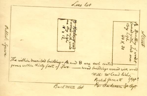
In 1837 McCandlish again insured his property in this area. The buildings were
represented on a plat as follows:

It is impossible from the records to determine just which of the buildings shown on these plats (or what portions of them) were located on that part of Block 8-2 which had formed the "Carter lot." As was true of the "Draper lot," the "Carter lot" appears again to have become a separate entity at a later date. [See abstract prepared by V. M. Geddy, July 9, 1928]
The history of the "Bucktrout-Lacey lot" (or "Bucktrout-Carey lot") is even more obscure than that of the "Carter lot" and the "Draper lot." From what has been said [see pages 7 and 8] it seems likely that Christopher Ayscough acquired a portion of this property sometime prior to 1769. In October, 1768, Christopher Ayscough advertised that he had "opened Tavern fronting the south side of the Capitol, Williamsburg." [Virginia Gazette, Purdie and Dixon, Editors, October 6, 1768]. In September, 1770, Ayscough advertised that he intended to "leave off tavern keeping," and offered for sale his property in this vicinity.
14September 20, 1770
As I intend to leave off tavern keeping, on Thursday the 27th instant will be exposed to sale my dwelling-house in this city, with a house adjoining, that was built for a store; there is a lot and a half of ground, and on it are all convenient outhouses, besides a well, and garden well paled in. At the same time will be sold all my HOUSEHOLD and KITCHEN FURNITURE, and nine NEGROES, one an exceeding good cook wench, and a fellow who is a very good gardener. Also about 60 dozen of good old MADEIRA WINE, a large quantity of COAL, five HORSES, a CART and HAFNE88. Six months credit will be allowed for all sums above 40s. the purchasers giving bond and security.
Those to whom I am indebted, upon coming to the sale, may purchase to the amount of their demands. As soon as it is ended I shall make over the bonds to my creditors.
CHRISTOPHER AYSCOUGHN.B. All persons indebted to me are desired to come, without fail, by the 25th of October next, and either pay or give bond and security for what they owe. No longer indulgence will be given.
[Virginia Gazette, Purdie and Dixon, Editors]
In October, 1771, Catharine Rathell advertised that she had opened a shop "where Mr. Ayscough lately lived, opposite to the South side of the Capitol."
October 10, 1771
Just IMPORTED from London, and to be SOLD for ready Money only, at the cheapest Rates, by the Subscriber, at her Shop where Mr. Ayscough lately lived, opposite to the South side of Capitol.
A GENTEEL Assortment of MERCURY, MILLINERY, JEWELLERY, &c…
As it was impossible to get a House on the main Street, the Subscriber hopes the little Distance will make no Difference to her former Customers. [Virginia Gazette, Purdie and Dixon, Editors]
In that same month, M. Brodie advertised that she was lodged "at Mrs. Rathell's Store, where Mr. Ayscough formerly lived, on the South Side of the Capitol, Williamsburg." The announcement follows:
M. BRODIE
Just arrived from LONDON
Makes and trims, in the newest Taste, Sacks and Coats, Gowns and Petticoats, all Sorts of Ladies Brunswick and Jesuit Dresses, Sultana Robes, Robedecores, &c. She served her Time, and was Successour, to the original Makers, at their Warehouse in Pall Mall; her Partner still continues to carry on the Business in London, by whose Assistance, and that of the Queen's Mantuamaker, she is every three Months to be supplied with the Fashions. This, added to great Diligence, and a strong Desire to please, she hopes will be a sufficient Recommendation to the Ladies to favour her with their Command, which she will most thankfully acknowledge, by showing a punctual Observance to their Time and Orders. Ladies whom it may not suit to come to Town may be fitted by sending her a Pattern. She lodges, till a more convenient House can be got, at Mrs. Rathell's Store, where Mr. Ayscough formerly lived, on the south Side of the Capitol, Williamsburg. [Virginia Gazette, Purdie and Dixon, Eds., October 24, 1771]
As has been pointed out [page 8], Matthew Holt opened a store "next Door to Mrs. Ayscough's" on April 23, 1772. By October of that year both Christopher Ayscough and his wife, Anne, had died. The following notice regarding their estates is given in the Virginia Gazette of October 15, 1772: 15
NOTICE is hereby given to all Persons having any Demands against the Estates of Christopher Ayscough, and AnneAyscough, deceased, to bring them in properly proved, that Provision may be made, if possible, to satisfy them; and those who are indebted to either of the said Estates are requested to make immediate Payment, or give Notes for what they justly owe to them. JACOB BRUCE, Administrator. [Virginia Gazette, Purdie and Dixon, Eds, October 15, 1772]
In January, 1773, John Brown, sheriff, advertised for sale the houses and lots in this area which had belonged to the late Christopher Ayscough.
January 7, 1773
Tobe SOLD tothehighestBidder, on the Premises, on Wednesday the27th Instant, (January) pursuant
to a Decree of James City Court,
THE HOUSES and LOTS, near the Capitol, belonging to the Estate of ChristopherAyscough, deceased. Three Months Credit will be allowed the Purchaser, on giving Bond, with approved Security to
JOHN BROWN, Sheriff [Virginia Gazette, Purdie and Dixon, Editors]
In February, 1773, Jacob Bruce advertised that he would soon move into the house lately occupied by Christopher Ayscough, where he would provide lodging for young gentlemen. Bruce had served as administrator of Ayscough's estate.
February 11, 1773
The Subscriber begs Leave to inform the Publick that he is about to remove to the House lately occupied by Christopher Ayscough, deceased, situated on the back Street, and fronting the south Side of the Capitol, where he purposes to keep private Lodging Rooms for Gentlemen who will be pleased to favour him with their Company. He thinks himself able to accommodate them with a great Deal of Conveniency, and promises that no Pains shall be spared on his Part to make their Entertainment agreeable.
JACOB BRUCE.N.B. He also would be willing to take any young Gentlemen as Boarders who may have Intentions of residing in Williamsburg.
[Virginia Gazette, Purdie and Dixon, Editors, February 18, 1773]
Bruce appears to have conducted a store and other enterprises at the time he resided in this area, as is indicated by the following notice: 16
Williamsburg, March 10, 1774
JUST IMPORTED from London, and to be sold at Mr. Bruce's Store on the south Side of the Capitol, Garden PEASE, BEANS, and CABBAGE SEED of different Sorts, and the earliest and best Kinds. [Virginia Gazette, Purdie and Dixon, Editors]
Bruce appears also to have acted as an agent for Robert Carter of Nomini Hall during the years 1772-1777. [cf. Manuscript Letter Book, Volume III, passim.]
Bruce died in 1778:
May 1, 1778
[deaths] Mr. JACOB BRUCE, of this city, one of the auditors of the publick accounts. [Virginia Gazette, Alexander Purdie, Editor]
[Virginia Gazette, Dixon and Nicolson, Editors]May 1, 1779
ALL persons having demands against the estate of the late JacobBruce, of this city, are requested to apply immediately for payment to Mr. JamesShields, sheriff of York county, and those indebted to the said estate are also desired to pay their respective balances to the said Shields, as the situation of the estate requires a speedy settlement.
RACHEL BRUCE, Administratrix
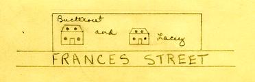
It does not appear from the records to whom Bruce's property in Capitol Square 8-2 went after his death. As has been pointed out, the two maps of Williamsburg made about the beginning of the nineteenth century indicate that the entire oblong lot extending lengthwise along Francis Street was then in the possession of persons named Bucktrout and Lacey or Bucktrout and Carey.
It seems probable that one portion of the Bucktrout-Lacey lot" came into the possession of Benjamin Bucktrout as early as 1774. On November 3 of that year, Bucktrout advertised goods for sale "in Francis Street, Williamsburg," as follows:
Just imported, and to be SOLD cheap for ready Money, by the Subscriber in Francis Street, Williamsburg, 17 Fine Bottled Porter, Taunton Beer, Gloucester Cheese, Negro Plains, Kendal Cottons, Plain and Striped Blankets, Fine Lustrings of different Patterns, Yorkshire Cloths, Patterns for Mens Surtout Coats, with Trimmings to each, Mens fine and coarse Hats, Velvet bound Hats with Roses, Mens Boots, Womens and Childrens Leather Shoes, Mens Gloves, Womens fine French Kid Gloves, Guns, Silver mounted and plain Pistols, Saddles complete, Whips, Hair Brooms and Brushes, Wool and Playing Cards, Horn Lanthorns, Plaistering Trowels, Sets of Types for marking of Linen, Checks and Striped Holland, Pepper, Allspice, Ginger, Paper Hangings for Rooms, Best Durham Mustard, Blue and White Water Jugs, Chamber Pots, Quart and Pint Mugs, Milk Pans, Sage and Balm Tea Pots, Coffin Furniture, Hair Seating for Chairs, Matrasses, Glass Salts, Vinegar Cruits, Salt, &c. &c. BENJAMIN BUCKTROUT. [Virginia Gazette, Purdie and Dixon, Eds., November 3, 1774, Postscript]
The following year, 1775, Benjamin Bucktrout advertised that he was still carrying on his business as a cabinet maker in Francis Street. The following advertisement appeared in the Virginia Gazette on February 4, 1775:
BENJAMIN BUCKTROUT
Cabinet Maker, in Francis Street, WILLIAMSBURG,
STILL carries on that Business in all its Branches, where Ladies and Gentlemen may be supplied with any Sort of Cabinet Work in the best and neatest Manner. I return those Ladies and Gentlemen who were pleased to favour me with their Commands, my most grateful thanks, and hope for a Continuance of their Favours, which to merit shall always be the Study of their most humble Servant.
BENJAMIN BUCKTROUT.N. B. I should be glad to take one or two Apprentices, of bright Genius, and of good Dispositions, and such whose Friends are willing to find them in Clothes.
[Virginia Gazette, Dixon and Hunter, Ed., February 4, 1775]
In 1777 John Hart and Company advertised that they would dispose of a cargo of goods at "Mr. Bucktrout's store." [Virginia Gazette, Alexander Purdie, Ed., February 24, 1777.] Bucktrout lived at this period at a house on the south side of Francis Street. [see Chiswell-Bucktrout house report and Virginia Gazette, October 2, 1779.] In 1779 he advertised this residence for sale. He described his residence as "very well calculated for a tavern." Bucktrout also offered for sale at this time "a chest of cabinet maker's and 18 house joiner's tools." [Virginia Gazette, Dixon and Nicholson, Editors, August 28, 1779]
As has been pointed out, one of the two maps of
Williamsburg, made about the beginning of the nineteenth century, showed that
persons named Bucktrout and Lacey owned together the entire oblong lot in this
area, extending along Francis Street. The other map indicates that a person or
persons named Bucktrout and a persons or persons named Carey owned the lot at
the time it was made. The position of the two structures on this block was
indicated on Bucktrout's map as follows:
As will be recalled, when Robert McCandlish insured his property on the south side of the Capitol Square in 1817, he stated that his property was bounded on the west by "Bucktrout's lot." Sometime between 1817 and 1836, it would appear that a portion of the "Bucktrout-Lacey lot" was incorporated into a larger property owned by Robert McCandlish and that another portion was acquired by a member or members of the Saunders family, for when McCandlish insured his property in 1836, he stated that his lot was bounded on the west by the Saunders lot and on every other side by streets. [see page 12]. It will be recalled that Charles stated that in 1861 an old lady, Miss Sarah Saunders, lived on a lot which was west of the McCandlish lot in this area.
Abstracts prepared by V. M. Geddy in 1927 and 1928 reveal that later in the nineteenth or early twentieth century, the "Bucktrout-Lacey lot" was subdivided in such a way as to form a portion of at least three modern lots, which extended lengthwise in a north-south direction and approximately to the line of the old enclosure which had stood about the Capitol grounds.
H. D. f.
Oct 28, 1940
H.D.F.
20.16
Footnotes
BOUNDS OF THE CAPITOL AND PRISON
DOCUMENTARY EVIDENCE
April 11, 19430
- 1.Survey of Williamsburg by Theodoric Bland - 1699
- 2. Map of Williamsburg about 1790 (College Library)
- 3. April 1699. Session 11th William III Act XIV Portion
only quoted as follows
II "Be it enacted, by the governor, council and burgesses of this present general assembly, and the authority thereof, and it is hereby enacted, that four hundred seventy five foot square of land, lying and being at the said middle Plantation, which hath been already agreed upon by his Excellency the Governor, Council and Burgesses, of this present General Assembly, to be taken up and surveyed, as a convenient place for such uses, be the ground appropriated to the only and sole use of a building for the General Assemblies and Courts to be held and kept in:" Etc.
- 4. Wednesday May the 3rd, 1704 Portion only quoted as
follows
"That ten acres of land be laid out for the bounds and rules of the Prison"
Journals of the House of Burgesses of Va. 1702-1712 - P. 64-65 - 5.Wednesday May the 10th, 1704 Portion only quoted as
follows
"Resolved: That the Publick Prison be included within the Bounds appropriated to the Capitol and that the sd. bounds already ascertained for the s'd Capitol be continued from the main road just before the door of one of the Capitol Houses to the extent of forty one poles to a post, thence including the prison, thirty two poles a post on the west side of the Spring, thence fourteen poles to the corner of a Ditch, thence along the said Ditch thirty poles and a half to a post by the said Ditch and from thence to the beginning place."
W. Randolph C1: Ho: Bur:
INTERPRETATION OF EVIDENCE
- A.
There seems to be no doubt about the "four hundred seventy five foot of land" surrounding the Capitol itself.
These boundaries coincide in a very significant manner with existing property lines and fences, notably on the east and west sides.
The dotted square A B C D ON THE MAP SHOWS THESE BOUNDS.
- B.
No. 4 appropriates ten acres for the Bounds and Rules of the Prison" and No. 5 states that "the Publick Prison be included within the Bounds appropriated to the Capitol."
It therefore seems reasonable to suppose that the "ten acres" would include the Capitol grounds as well as the Prison grounds especially as ten acres for the Prison alone would be unreasonably large. Larger in fact than the Capitol grounds.
- C.
If the "Spring" (mentioned in No. 5) could be located there would not be much doubt as to how the bounds were laid out.
There seems to be no evidence at present of any spring in the vicinity of the Capitol but the 1790 Map (No. 2) shows on lots 276 - 277 "Greenhow" a spring"
These lots join the Prison lots on the west.
- D.
It should be borne in mind that the Bland Survey (No. 1) shows the Duke of Gloucester Street running some distance east of the Capitol. Therefore "The main road just before the door of one of the Capitol houses" (No. 5) might refer to either the west of east sides of the building.
Given the 475 foot square around the Capitol, if the side A-B on the east is prolonged to the north to an extent of 41 poles (676 feet) we reach a point E (at the N.E. corner of the present Garrett house). From this point as a centre an arc is swung to the west with a radius of 32 poles (528 ft.)
If the west side of the 475 foot square is prolonged to the north to an extent of 30-1/2 poles, (503.25 feet) we reach a point G. From this point as a center an arc is swung to the north with 14 poles (231 ft.) as a radius. The intersection of this arc and the former one fix the point F., which falls inside the lots 276-277 where the spring was noted on the 1790 map.
In reading the description (No. 5) of the bounds once again it will be seen that every landmark (except the posts) seems to be accounted for by this diagram "The Post on the west side of the spring" (Point F) seems properly located, "thence four teen poles to the corner of a Ditch" (Point G) falls near the intersection of two small ravines (see contour map) "thence along said ditch thirty poles and a half to a post by the said Ditch (Point D)" follows the present small ravine perfectly, crossing where the modern Duke of Gloucester Street has filled it in; "from thence to the staring point" brings us back to A., along the southern boundary of the Capitol Grounds.
This diagram AEFGD - A encloses an area of about 8 acres modern measurement. We have been unable to find out if the acre of 1704 was the same as at present, namely 43,560 sq. ft.
Perry, Shaw & Hepburn
Architects
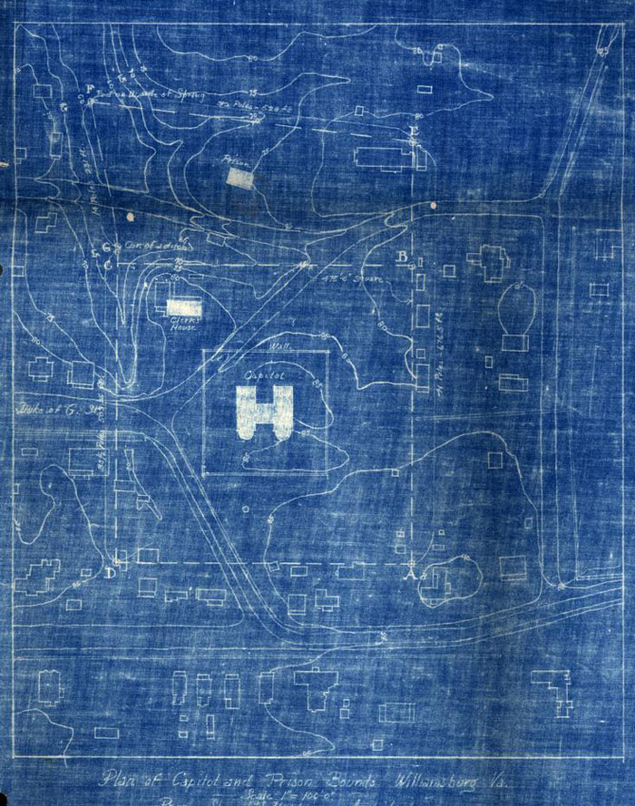 Plan of Capitol and Prison Bounds, Williamsburg, Va.